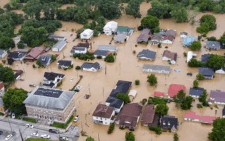
Section of Nairobi Bound Lanes along Kenol – Sagana Road closed
The Kenya National Highways Authority (KeNHA) has announced the closure of a section of Nairobi Bound Lanes along the Kenol-Sagana (A2) Road.
KeNHA said the closure is due to heavy rains causing debris to fall from the back slope of the road section at the Mugetho area.
The highway authority expressed regret over the necessity of the closure.
“The Kenya National Highways Authority regrets to notify the public of the closure of a section of the Nairobi Bound Lanes along Kenol Sagana (A2) Road. This follows the heavy rains that led to debris falling from the back slope of the road section at Mugetho area,” a statement by KeNHA read in part.
Motorists travelling in the affected area are directed to share lanes with the Sagana Bound Traffic and to adhere to instructions provided by traffic marshals at the location.
KeNHA assured the public that efforts are underway to restore normal traffic flow as swiftly as possible.
“Motorists are advised to share lanes with the Sagana Bound Traffic and adhere to instructions provided by traffic marshals at the location as the Authority works to restore the normal traffic flow. The Authority remains committed to ensure seamless connectivity to facilitate safe passage of goods and services for economic prosperity. At KeNHA, your safety is our utmost priority,” KeNHA said
Closure of a section of the Nairobi Bound Lanes along Kenol – Sagana Road pic.twitter.com/Jk6aBbtgTM
— Kenya National Highways Authority (KeNHA) (@KeNHAKenya) May 8, 2024
Floods to persist
With the ongoing heavy torrential rains, transport has been impaired due to flooding rendering most roads impassable.
On Wednesday, May 8, government Spokesperson Isaac Mwaura mentioned that heavy rainfall and thunderstorms are expected to persist in 31 counties, particularly affecting areas such as the Lake Victoria Basin, Rift Valley, Central, and Eastern regions.
The forecast also includes occasional rainfall in Nairobi and along the Coast region, impacting several counties including Tana River, Kwale, Mombasa, Kilifi, and Lamu.
Mwaura highlighted the continued risk of flooding in regions adjacent to Lake Victoria and Lake Baringo due to backflow, as well as potential overflow from Seven Forks Dams, which could lead to increased flooding in the Tana Delta and the Garissa, Tana River, and Lamu counties.
Furthermore, he mentioned that 61 health facilities in 11 counties have been affected, and approximately 9,816 acres of crops have been destroyed.
“Additionally, 61 health facilities have been affected in 11 Counties and crops on approximately 9,816 acres of land have been destroyed,” he said.
Mwaura said the government is actively involved in ensuring the safety of families at risk, including evacuating households within riparian corridors in Nairobi and areas prone to landslides and mudslides.
Notices have also been issued for sections along Kenya railway tunnels to facilitate rehabilitation efforts.
Mwaura noted the provision of logistical support, temporary shelter, and essential supplies to affected households.
However, he noted the need for additional food, medical kits, and non-food items in affected counties, where search and rescue operations are ongoing, particularly in Narok, West Pokot, Nyeri, Siaya, and Kirinyaga.


